
A state in two parts
Hands up if you’ve ever given much thought to Michigan. (Unless you live there, of course.) What do you know about it? I’ll go first: Detroit, which is famous for making cars and Motown music; my partner Mike did his post-grad in Ann Arbor; swing state; one of the states where armed MAGA heads tried to storm the state capital and some plotted to kidnap and execute the governor, Gretchen Whitmer.

That’s pretty much it for me. If I’d ever given any thought to what it looked like, I would have said an oven mitt.
Then last night, as I was fast forwarding through the ads in a show I’d taped from one of the Detroit stations bizarrely provided as part of my cable package, an image of the state flew past as part of a trailer for the news and weather. I hit stop then rewound a bit.
This is what I saw.
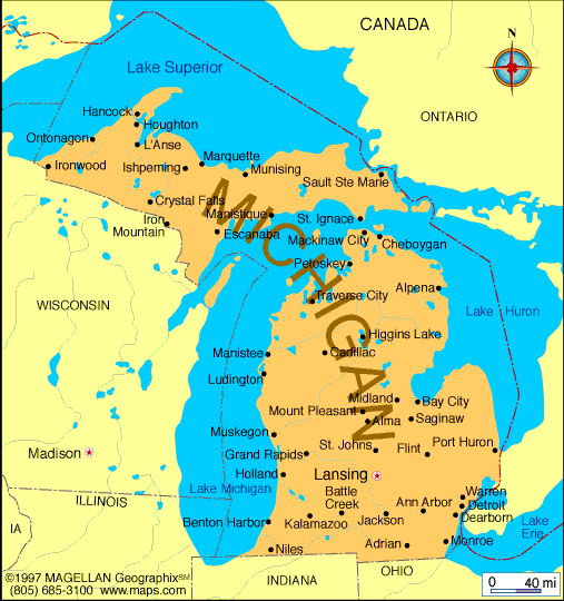
Huh?
Perhaps US students, who are only taught (white) US history from 1492 to the present, are also only taught US geography and are therefore familiar with the size and shape of every state in the union. Perhaps they are aware that this is a state in two parts which borders on four of the five Great Lakes.
How did this happen? Why is the upper part not part of Wisconsin?
Well, let me tell you, because my curiosity was piqued and I’ve done some research. According to NPR:
“In the late eighteenth century, the United States acquired (for “acquired” read “stole from the native population”) “the land that would later become Illinois, Indiana, Michigan, Ohio and Wisconsin, and adopted the Northwest Ordinance of 1787, laying out how new states could be admitted into the Union. Areas became territories, and territories started to become states.
“Unfortunately, some of the boundaries weren’t well-defined, causing the state of Ohio and the territory of Michigan to fight over a less than 500-square-mile piece of land called the Toledo Strip that encompassed modern-day Toledo and Maumee Bay on Lake Erie.”
This led to the Toledo War between the state of Ohio and the territory of Michigan.
According to another source:
“The Toledo War involved more saber-rattling and one-upmanship than it did shooting and blood-letting. The only casualty listed was that of a Michigan sheriff who was stabbed by an Ohioan during a tavern fight.”
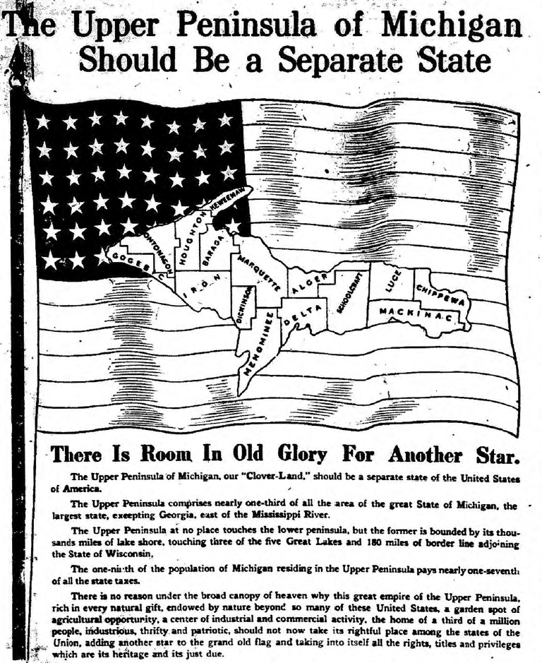
This non-war dragged on for years until eventually the territory of Michigan (at that time just the oven mitt) was told it would only qualify for statehood if it stopped banging on about the Toledo Strip and instead accepted the Upper Peninsula. Michigan’s initial reaction, apparently, was “No, we want the Toledo Strip. The Upper Peninsula doesn’t have anything but ice and rock and trees. And we don’t want that.” But states qualified for federal funding that territories didn’t, so the compromise was grudgingly accepted.
For 120 years the only way to get from the Upper Peninsula to the Lower Peninsula was by boat. In 1957 the Mackinac Bridge physically linked the state’s two parts for the first time. Fun fact: the 7400-foot bridge is the longest suspension bridge in the Western Hemisphere.
Generally speaking, the bridge is pretty much the only thing that links the two parts. Upper Peninsula residents resent the power imbalance with the Lower Peninsula. In the mid 19th century they began to petition to become a separate state (humbly named Superior) and quite a few would still like to see this happen.
There you go. As Trevor Noah would say, if you didn’t know that, now you do.
Learn something new every day.

And I thought Sault Ste. Marie was in Ontario (which it is, but apparently there’s one in Michigan, too).
Indeed.
There’s also a Vancouver in Washington state.
Strangely enough, I got drawn into maps of Michigan when reading Station Eleven. Compelled to look up Traverse city and towns real and fictional (and which fictional ones might correspond to real ones). But didn’t know the “war” history — so thanks. Qualifies as my ‘learn something new’ for today.